
 European Water Archive
 Satellite derived snow
 Flash floods and geocomputation
Flash-Floods and Geocomputation
Recent research
Although in recent decades there have different research advancing in geocomputation, only few applications have been addressed towards extreme weather events to be used in hydrological risk assessment and landscape responses (Heneker et al., 2001). Also regional warning systems for debris and mudflows following heavy rainfall have been few developed (Smith, 2004), although the first public landslides warning in USA were issued in 1986. In this context, in fact, geocomputational models suffers from several limitations, where temporal variability – hourly and sub hourly (Fig. 4) – in rainy forcing and land response has been largely ignored (Tucker et al., 2002).
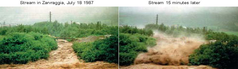
View of a typical flashflood evolution (from: Swiss Federal Office for the Environment-FOEN).
Heneker, T.M., Lambert, M.F., Kuczera, G., 2001. A point rainfall model for risk-based design. Journal of Hydrology 247, 54-71.
Smith, K., 2004. Environmental Hazards: Assessing Risk and Reducing Disaster. Routledge, 306 pp.
Tucker, G.E, Stephen T. Lancaster, Nicole M. Gasparini, Rafael L. Bras, 2002. The Channel-Hillslope Integrated Landscape Development Model (CHILD).
1) from: GIScience Satellite and Land Data Assimiliation Model for Rainstorms Hazard Mapping, by Nazzareno Diodato, Report of TEDASS – Technologies Interdepartmental Center for Environmental Diagnostic and Sustainable Development, University of Sannio, 82100 Benevento (Italy).

|
© 2016 EURO-FRIEND
|
Top 
|


River Trent, Nottingham, UK
Heavy rain, Penang, Malaysia