
 European Water Archive
 Satellite derived snow
 Runoff generation
Spatial responses of hydrological models: understanding runoff generation
Recent research
In small catchments the investigation of spatial responses means to find out if the wetting of the catchment in the model agrees with the reality. Various procedures can be used from the simple mapping of the saturated areas during wet and dry events on the catchment (e.g. Blazkova et al., 2002a) to more sophisticated using a large number of piezometers (Blazkova et al., 2002b). At present the functioning of drainage ditches serves as information on the wetness of a small catchment using a linguistic fuzzy description.
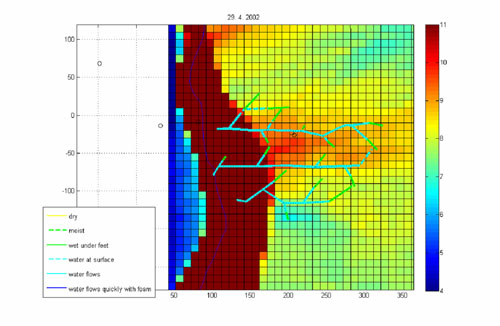
Wetness of observed drainage ditches after the end of snowmelt with a linguistic scale plotted on the map of the topographic index ln(a/tg β), where a is the catchment area drained to a certain point and β is the slope at that point. The grids with higher values mark places which are usually wet (near the streams). Site: Uhlirska in the Jizera Mountains
For more information contact: Sarka Blazkova and Alena Kulasova

|
© 2016 EURO-FRIEND
|
Top 
|


River Trent, Nottingham, UK

Heavy rain, Penang, Malaysia
(06.11.2007, 95 KB)